Information of Paper
Authors:Ronald C. Estoque, Robert G. Pontius Jr, Yuji Murayama, Hao Hou, Rajesh B. Thapa, Rodel D. Lasco, and Merlito A. Villar
Year:2018
Journal:International Journal of Applied Earth Observation and Geoinformation 67: 123–134
Link to the paper
Keywords
ALOS; CCI; Forest; Global tree canopy; GLOBELAND30; Google Earth; LANDSAT; MODIS; NAMRIA; Philippines; Remote sensing
Abstract
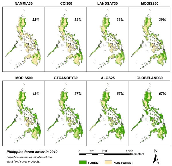
This article compares and assesses eight remotely sensed maps of Philippine forest cover in the year 2010. We examined eight Forest versus Non-Forest maps reclassified from eight land cover products: the Philippine Land Cover, the Climate Change Initiative (CCI) Land Cover, the Landsat Vegetation Continuous Fields (VCF), the MODIS VCF, the MODIS Land Cover Type product (MCD12Q1), the Global Tree Canopy Cover, the ALOSPALSAR Forest/Non-Forest Map, and the GlobeLand30. The reference data consisted of 9852 randomly distributed sample points interpreted from Google Earth. We created methods to assess the maps and their combinations. Results show that the percentage of the Philippines covered by forest ranges among the maps from a low of 23% for the Philippine Land Cover to a high of 67% for GlobeLand30. Landsat VCF estimates 36% forest cover, which is closest to the 37% estimate based on the reference data. The eight maps plus the reference data agree unanimously on 30% of the sample points, of which 11% are attributable to forest and 19% to non-forest. The overall disagreement between the reference data and Philippine Land Cover is 21%, which is the least among the eight Forest versus Non-Forest maps. About half of the 9852 points have a nested structure such that the forest in a given dataset is a subset of the forest in the datasets that have more forest than the given dataset. The variation among the maps regarding forest quantity and allocation relates to the combined effects of the various definitions of forest and classification errors. Scientists and policy makers must consider these insights when producing future forest cover maps and when establishing benchmarks for forest cover monitoring.


