
Initial analysis results of focus-mode observation data from the Total Anthropogenic and Natural emissions mapping SpectrOmeter-3 (TANSO-3) onboard the Global Observing SATellite for Greenhouse gases and Water cycle (GOSAT-GW, “IBUKI GW”)
1. Summary
The National Institute for Environmental Studies (NIES), in cooperation with the Ministry of the Environment of Japan (MOE) and the Japan Aerospace Exploration Agency (JAXA), has been observing atmospheric gases, such as carbon dioxides (CO2) and methane (CH4), by utilizing the Greenhouse Gases Observing Satellite (GOSAT) series. The aim has been to advance climate change science and support evaluation of climate change policies and initiatives.
The third satellite in the series, the Global Observing SATellite for Greenhouse gases and Water cycle (GOSAT-GW, “IBUKI GW”)*1, jointly developed by the MOE, NIES, and JAXA, was successfully launched at 1:33 a.m. on June 29, 2025 (JST). Following completion of initial functional verification operations*2, GOSAT-GW entered its nominal operation phase on October 9, 2025.
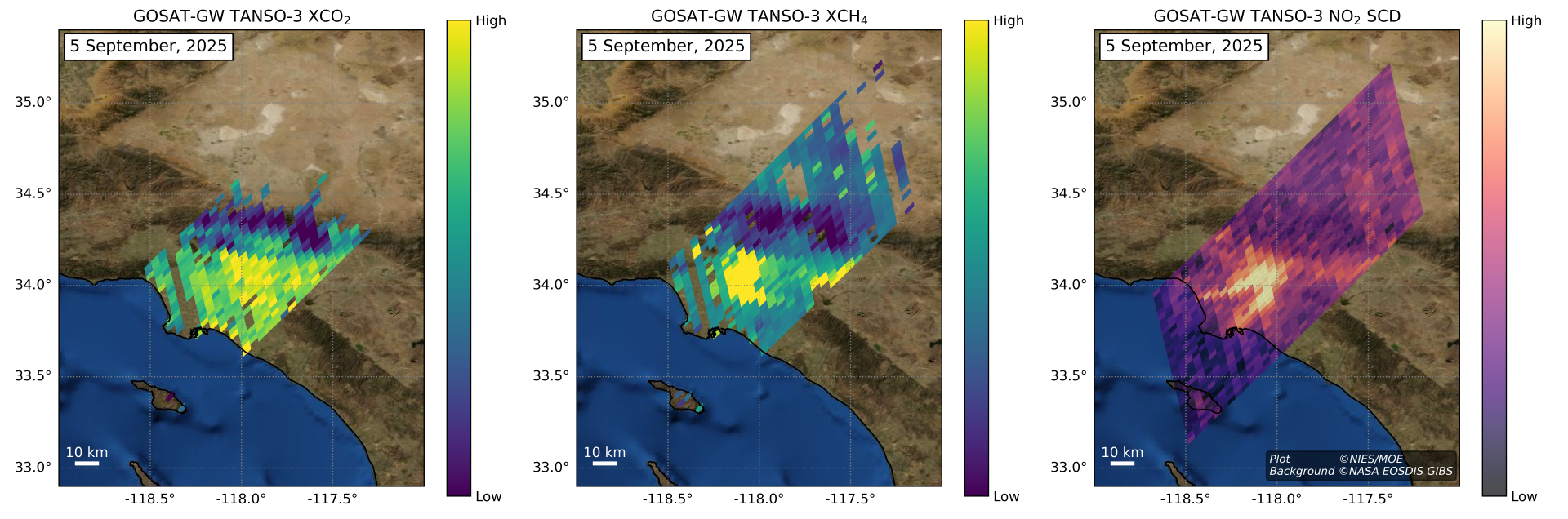
The instruments onboard GOSAT-GW include the Total Anthropogenic and Natural Emissions Mapping SpectrOmeter-3 (TANSO-3), which has two observation modes: wide mode and focus mode. The wide mode observes Earth’s surface with a swath of at least 900 km and a spatial resolution of around 10 km, while the focus mode targets finer areas, such as urban regions, with a swath of at least 90 km and a spatial resolution of 1–3 km. NIES recently completed an initial analysis of focus-mode observations and derived distributions of the concentration of CO2, CH4, and nitrogen dioxide (NO2) over a metropolitan area of the United States (Figure 1). This represents the world‘s first satellite-based observation to capture the distributions of these gases as imagery within a single field of view and at the same time. The results were presented at the 30th Conference of the Parties to the United Nations Framework Convention on Climate Change (UNFCCC COP30), held in Belém, Brazil, in November 2025.
2. Background and Objective
The GOSAT satellite series is designed to observe greenhouse gases such as CO2 and CH4 from space. The series currently includes three satellites: the Greenhouse gases Observing SATellite (GOSAT, “IBUKI”) launched in 2009, the Greenhouse Gases Observing SATellite 2 (GOSAT-2, “IBUKI-2”) launched in 2018, and now GOSAT-GW launched on June 29, 2025.
The Sixth Assessment Report (Working Group I) published by the Intergovernmental Panel on Climate Change (IPCC) in August 2021 states that “It is unequivocal that human influence has warmed the atmosphere, ocean and land” and that “Limiting human-induced global warming to a specific level requires limiting cumulative CO2 emissions, reaching at least net zero CO2 emissions”. Under the Paris Agreement, all Parties are required to prepare national commitments to reduce carbon emissions and to steadily achieve these commitments. In this context, satellite observations of atmospheric greenhouse gases are expected to contribute to improving the transparency of emission reports published by countries that have ratified the Paris Agreement. GOSAT-GW carries two mission instruments: the Total Anthropogenic and Natural emissions mapping SpectrOmeter-3 (TANSO-3) and the Advanced Microwave Scanning Radiometer 3 (AMSR3). The TANSO-3 instrument and its ground systems were jointly developed by the MOE and the NIES, with the JAXA also involved in the development and operation of TANSO-3 under contract with the MOE. The NIES is responsible for using TANSO-3 to estimate CO2, CH4, and NO2 concentrations as well as for the production, validation, publication, and long-term preservation of the data products.
3. Greenhouse Gas Analysis and Results
NIES retrieved column-averaged concentrations of CO2 and CH4 (XCO2 and XCH4) from non-calibrated spectral data (L1B V001.001) acquired by TANSO-3 in focus mode (3-km resolution) over the Los Angeles metropolitan area of the United States on September 5, 2025. To retrieve the concentrations, the spectral region around 1.6 µm observed by Band 3—one of the three TANSO-3 bands that covers wavelengths corresponding to CO2 and CH4 absorptions—was divided into separate wavelength ranges for CO2 and CH4. Spectral fitting using the maximum a posteriori*5 method was applied to each range to simultaneously estimate XCO2 or XCH4 along with the other parameters. XCO2 (Figure 1, left) and XCH4 (Figure 1, center) values were screened based on spectral quality and the accuracy of the spectral fitting. Enhanced XCO2 and XCH4 concentrations were observed in urban area, suggesting the possibility of detecting increases associated with anthropogenic emissions; however, these values should be interpreted with caution as they were derived from a simplified retrieval processing without accounting for aerosols using non-calibrated spectra and may be significantly influenced by surface conditions and other factors.
4. NO2 Analysis and Results
Slant column density (SCD) of NO2 (Figure 1, right) was estimated using the Differential Optical Absorption Spectroscopy (DOAS) method applied to radiance and solar irradiance spectra observed by TANSO-3 over the Los Angeles metropolitan area on September 5, 2025. DOAS is a widely used technique for retrieving NO2 columnar concentrations from satellite observations. This method is based on the Beer-Lambert law*6 and involves spectral fitting to the differential optical thickness*6 of the target gas. The fitting uses absorption cross-section*7 data for NO2 and other gases, such as ozone and water vapor, that absorb light within the visible wavelength range observed by Band 1 of TANSO-3. Elevated NO2 SCD values were observed over the target area (Figure 1, right), indicating qualitative capture of both the increase of NO2 likely originating from coastal emission sources and the movement of the emitted plume*8. Thus, NO2 SCD values are expected to improve the identification of CO2 emission sources from fossil fuel combustion, since CO2 is inherently co-emitted with NO2, and to enhance the accuracy of emission estimates, thereby contributing not only to scientific research but also to broader societal benefits.
5. Prospects
TANSO-3 products include Level 1B products, which contain radiance spectral data, and Level 2 products, which contain XCO2, XCH4, and NO2 SCD data, as used in the recent analysis. Public release of the Level 1B products, following careful calibration and validation to ensure adequate quality, is scheduled for spring 2026, while the release of the Level 2 products is planned for spring 2027.
GOSAT-GW is currently in nominal operation, with observations primarily focused on the calibration*9 of TANSO-3, which is being conducted by the JAXA. The NIES is performing initial analyses using preliminary radiance spectral data provided by the JAXA and sharing the results with the JAXA to support improvements in calibration. Once a sufficient level of calibration is achieved, efforts will proceed to validation, which will involve evaluating the accuracy and precision of the Level 2 products using independent observations. These activities—calibration, processing of higher-level data products, and validation—are being conducted mainly by the NIES, JAXA, and MOE in close collaboration with domestic and international research institutions and universities.
Three missions, based on TANSO-3 observations, are set: monitoring of global monthly mean concentrations of atmospheric CO2, verifying reported national estimates of anthropogenic greenhouse gas emissions, and monitoring of major greenhouse gas emission sources such as metropolitan areas, power plants, and permafrost regions. Through achievement of these missions, contributions toward mitigating climate change driven by increasing greenhouse gas concentrations in Earth‘s atmosphere are pursued in coordination with GOSAT and GOSAT-2.
6. Operational Framework at NIES
-
Estimation of atmospheric concentrations of CO2 and CH4 using TANSO-3 data:
Yu Someya, Senior Researcher
-
Estimation of NO2 column densities using TANSO-3 data:
Tamaki Fujinawa, Senior Researcher
Hyunkwang Lim, Research Associate -
Development of ground data processing system:
Hisashi Yashiro, Senior Researcher
Tazu Saeki, Senior Researcher
Takashi Sugita, Chief Senior Researcher
Yosuke Yamashita, Senior Researcher
-
Progress management and related tasks:
Hiroshi Tanimoto, Earth System Division Director
Tsuneo Matsunaga, Satellite Observation Center Director
Isamu Morino, Satellite Remote Sensing Research Section Head
7. Acknowledgements
We express our sincere gratitude to the Japan Aerospace Exploration Agency and Mitsubishi Electric Corporation for their support in the initial analysis of the TANSO-3 data. The development of algorithms for NO2 observations, validation measurements and analyses, and related application studies were conducted under a tripartite collaborative research agreement among the NIES, the Japan Agency for Marine-Earth Science and Technology (JAMSTEC), and the National Institute of Information and Communications Technology (NICT). We also acknowledge the use of QDOAS (https://uv-vis.aeronomie.be/software/QDOAS/(Clicking this link will lead to an external site)), a community-based free software, for DOAS calculations.
8. Annotations
1. IBUKI GW (GOSAT-GW: Global Observing SATellite for Greenhouse gases and Water cycle)
A satellite that observes Earth’s water cycle and greenhouse gases from space. It carries two mission instruments: the Total Anthropogenic and Natural emissions mapping SpectrOmeter-3 (TANSO-3) and the Advanced Microwave Scanning Radiometer 3 (AMSR3). The MOE and the NIES lead greenhouse gas observations using TANSO-3, while the JAXA leads water cycle observations using AMSR3.
2. Initial functional verification operations
Operations conducted to verify that the satellite and its onboard sensors achieve the specified functional performance in orbit.
3. Column-averaged concentration
The ratio of the total column amount of a greenhouse gas to the total column amount of dry air, where the column amount is defined as the number of gas molecules per unit area in a vertical column extending from Earth’s surface to the top of the atmosphere.
4. Slant column density
The total number of gas molecules contained in a slanted column along the optical path of sunlight—from the Sun, through Earth’s atmosphere, to the satellite—rather than in a column perpendicular to Earth’s surface.
5. Maximum a posteriori method
An estimation technique widely used in atmospheric remote sensing of greenhouse gases with spectral sensors. It defines a cost function based on the difference between theoretical calculations and observations, as well as deviations of estimated variables from their a priori values, taking into account the error distributions of both observations and a priori values. By iteratively minimizing this cost function, the most probable estimates of the variables are obtained.
(Rodgers, C. D.: Inverse Methods for Atmospheric Sounding: Theory and Practice, World Scientific, 2000.)
6. Beer-Lambert Law and optical thickness
The Beer-Lambert law describes the relationship between the amount of light absorbed as it passes through a substance (such as a gas) and the concentration of that substance. The degree of absorption of sunlight by the atmosphere, referred to as the optical thickness, can be quantified by comparing the intensity of sunlight outside Earth’s atmosphere with that after absorption and scattering in the atmosphere and return to space. From this optical thickness, the concentration of the absorbing gas can be estimated.
7. Absorption cross-section
A physical quantity that represents the efficiency with which a substance (gas) absorbs light at a given wavelength.
8. Plume
A mass of air containing atmospheric pollutants and greenhouse gases emitted from a source.
9. Calibration
The process to characterize the accuracy and precision of radiance spectra, primarily in radiometric, spectroscopic, and geometric aspects. Before launch, TANSO-3 was calibrated radiometrically and spectrally by laboratory-based methods using integrating spheres and lasers. After launch, calibration is performed using several methods, including using reflected sunlight from an onboard solar diffuser, sunlight reflected from the lunar surface, and ground-based calibration targets.
9. Reference websites
NIES GOSAT-GW Project
https://gosat-gw.nies.go.jp/en/index.html
Press release “GOSAT-GW (‘IBUKI GW’) Successful Launch and Completion of Critical Operations Phase”
https://www.nies.go.jp/whatsnew/20250701/20250701-e.html
Press release “First observations by the Total Anthropogenic and Natural emissions mapping SpectrOmeter-3 (TANSO-3) onboard the Global Observing SATellite for Greenhouse gases and Water cycle “IBUKI GW” (GOSAT-GW)”
https://www.nies.go.jp/whatsnew/20250826/20250826-e.html
10. Contacts
[Contact for this research]
Satellite Observation Center
National Institute for Environmental Studies
E-mail: soc-info (please append ‘@nies.go.jp’ to complete the email address)
[Contact for this press release]
Public Relations Office, Planning Division
National Institute for Environmental Studies
Email: kouhou0 (please append ‘@nies.go.jp’ to complete the email address)
- What's New
- What's New 2025
- What's New 2024
- What's New 2023
- What's New 2022
- What's New 2021
- What's New 2020
- What's New 2019
- What's New 2018
- What's New 2017
- What's New 2016
- What's New 2015
- What's New 2014
- What's New 2013
- What's New 2012
- What's New 2011
- What's New 2010
- What's New 2009
- What's New 2008
- What's New 2007
- What's New 2006
- What's New 2005
- What's New 2004
- What's New 2003
- What's New 2002
- Event Information
- Visit NIES