Update on the analysis method to estimate the greenhouse gas concentrations from GOSAT
1. Background and objectives
The Greenhouse gases Observing SATellite (GOSAT) that is the joint mission of the Ministry of Environment, the National Institute for Environmental Studies (NIES), and the Japan Aerospace Exploration Agency has observed almost continuously since its launch and is currently in operation.
Thermal And Near-infrared Sensor for carbon Observation – Fourier Transform Spectrometer (TANSO-FTS) onboard GOSAT observes the shortwave infrared (SWIR) spectra(*1). The carbon dioxide (CO2) and methane (CH4) concentrations can be estimated by analyzing the spectra. NIES publicly provides these concentrations as the level 2 product. In the analysis, the observations with clouds in its field of view are not processed because the atmospheric particles such as clouds and aerosols are the large error sources of the estimation of the greenhouse gas concentrations. The number of data of only several percent is available as level 2 data due to this filtering. The updated analysis method changes the treatment of clouds to make available the scenes contaminated by optically thin clouds. Additionally, the supplemental information was also updated. These updates were performed to aim for the increase in the available data amount of the greenhouse gas concentrations and to improve their accuracies.
2. Methodology
The analysis method to estimate the greenhouse gas concentrations from the SWIR spectra observed by GOSAT developed in NIES estimates the parameters related to aerosols simultaneously to take into account their effects that are large uncertainty sources on the analysis (*2). The updated analysis method was improved to estimate cloud parameters instead of rejecting the scenes contaminated by optically thin clouds. This update enables us to analyze the scenes with optically thin clouds previously excluded in the processing. Additionally, we updated the sensitivity degradation model of TANSO-FTS (*3), solar irradiance spectra, and the database of absorption strength by greenhouse gases.
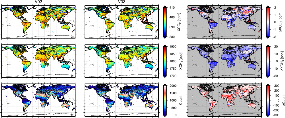
Approximately 13 years (from April 2009 to December 2021) of the observed spectra from GOSAT were analyzed using the updated analysis method to estimate CO2 and CH4 concentrations. The results were compared with the results from the method before the update, the data from the ground-based FTS network (TCCON), and the data from in situ measurements such as aircraft and ships to evaluate data amount and their accuracies.
3. Result and discussion
Comparison studies of the results using the updated method with the TCCON data or the results using the method before the update reveal that the updated method increases about 13% of the number of CO2 concentration data by approximately the same quality as the method before the update over land. However, the number of data decreased by about 20% with the larger negative biases over the ocean. The number of data on CH4 is approximately the same as CO2. The estimated values of CH4 from the updated method are generally lower and the accuracy is the same or slightly better than those from the method before the update.
It is known that the long-term CO2 growth rate estimated from the CO2 concentrations over the ocean from the method before the update is smaller than that from the in situ measurements. Similar evaluations using the results from the updated method revealed that the decadal CO2 growth rate over the ocean improved from the underestimate of 1.68 ppm/decade to 0.01 ppm/decade compared with that from the in situ measurements.
4. Outlook
The CO2 and CH4 concentrations estimated by the updated method are planned to publish as V03.00. The increase in the data may contribute to the improve the quality of the source/sink product, which is the higher-level product. On the other hand, the V03.00 product has negative biases over the ocean. Therefore, we plan to release the bias-corrected one as V03.05. The biases are possibly due to the fitting accuracy of the spectra (*5). We will continue to improve the method through further analysis to resolve this issue.
5. Annotations
*1: TANSO-FTS observes the spectral region called shortwave infrared (SWIR) near 0.7, 1.6, and 2.0 µm by the band 1 – 3 respectively.
*2: Light incident to the Earth’s atmosphere is reflected by the surface and reaches the satellite. The greenhouse gas observation from the SWIR spectra obtained from the satellite uses the absorption of the light on this path by the gases. Atmospheric particles such as clouds and aerosols change the absorption strength of the gases in the observed spectra through interactions, scattering, or absorption. Therefore, an accurate estimate of the greenhouse gases requires taking into account their contributions.
*3: The radiometric sensitivity in the SWIR band of TANSO-FTS has degraded with time from the launch. That is, the light of the same intensity incoming to the sensor optics is observed as the different intensities depending on the period from the launch. The analysis method to estimate greenhouse gas concentrations developed by NIES take into account this issue by using the degradation model.
*4: The greenhouse gas concentrations estimated from GOSAT and the other satellite are validated with the ground-based FTS network, Total Carbon Column Observing Network (TCCON; http://www.tccon.caltech.edu/) that has approximately 30 observation sites in the world. This dataset has higher accuracy than those from the satellites and is appropriate to use for validation studies.
*5: Greenhouse gas concentration estimates are based on the spectral fitting between observed and theoretical spectra calculated by assuming the atmospheric and surface states. In this procedure, we look for the theoretical spectra consistent with the observed spectra by changing the target parameters such as greenhouse gas concentrations.
6. Funding
This work was supported by the NIES GOSAT project. The Ministry of Environment-commissioned project supported parts of the TCCON and in situ measurements which are used in the validation studies.
7. About the article
【Article title】
Update on the GOSAT TANSO-FTS SWIR Level 2 retrieval algorithm
【Authors】
Someya, Y., Y. Yoshida, H. Ohyama, S. Nomura, A. Kamei, I. Morino, H. Mukai, T. Matsunaga, J. L. Laughner, V. A. Velazco, B. Herkommer, Y. Té, M. K. Sha, R. Kivi, M. Zhou, Y. S. Oh, N. M. Deutscher, and D. W. T. Griffith
【Journal】Atmospheric Measurement Techniques
【URL】https://amt.copernicus.org/articles/16/1477/2023/
【DOI】10.5194/amt-16-1477-2023
8. Author of this press release
National Institute for Environmental Studies
Satellite Remote Sensing Section, Earth System Division
Yu Someya (Senior Researcher)
Yukio Yoshida (Senior Researcher)
Hirofumi Ohyama (Senior Researcher)
Isamu Morino (Head)
Satellite Observation Center, Earth System Division
Akihide Kamei (Expert)
Tsuneo Matsunaga (Director)
Earth System Division
Hitoshi Mukai (Expert)
9. Contact
Satellite Remote Sensing Section, Earth System Division
Yu Someya (Senior Researcher)
- What's New
- What's New 2025
- What's New 2024
- What's New 2023
- What's New 2022
- What's New 2021
- What's New 2020
- What's New 2019
- What's New 2018
- What's New 2017
- What's New 2016
- What's New 2015
- What's New 2014
- What's New 2013
- What's New 2012
- What's New 2011
- What's New 2010
- What's New 2009
- What's New 2008
- What's New 2007
- What's New 2006
- What's New 2005
- What's New 2004
- What's New 2003
- What's New 2002
- Event Information
- Visit NIES